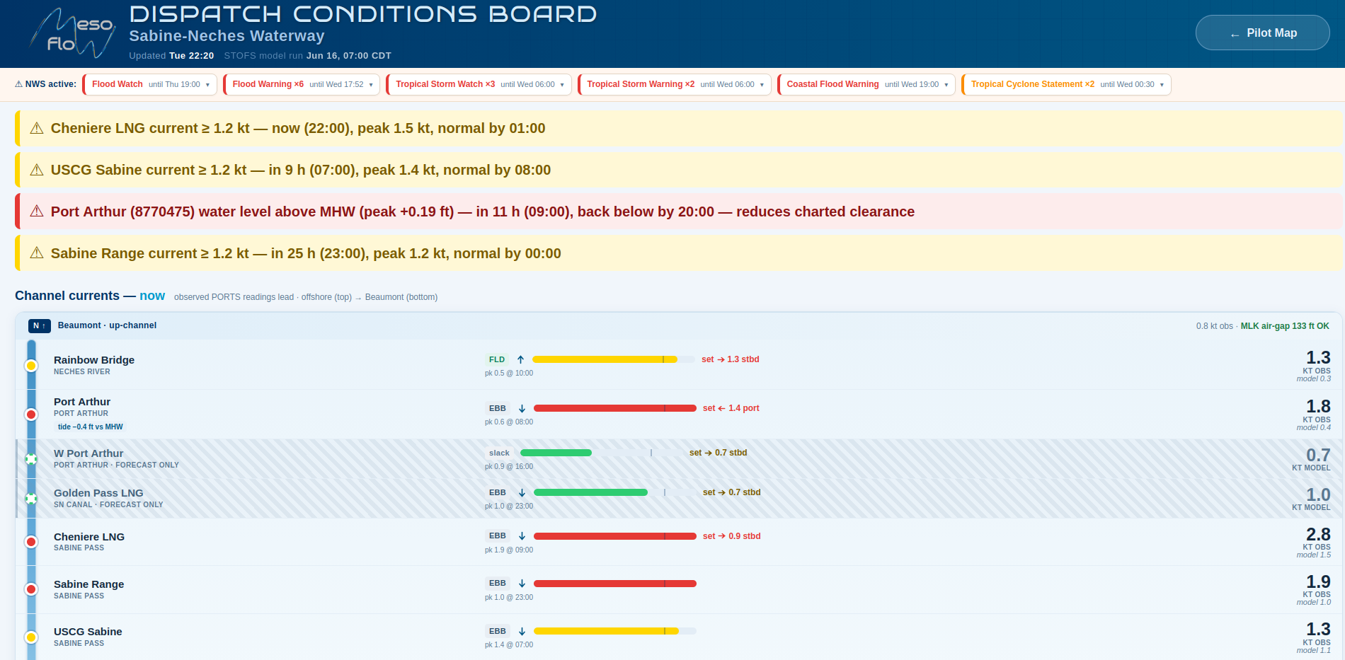
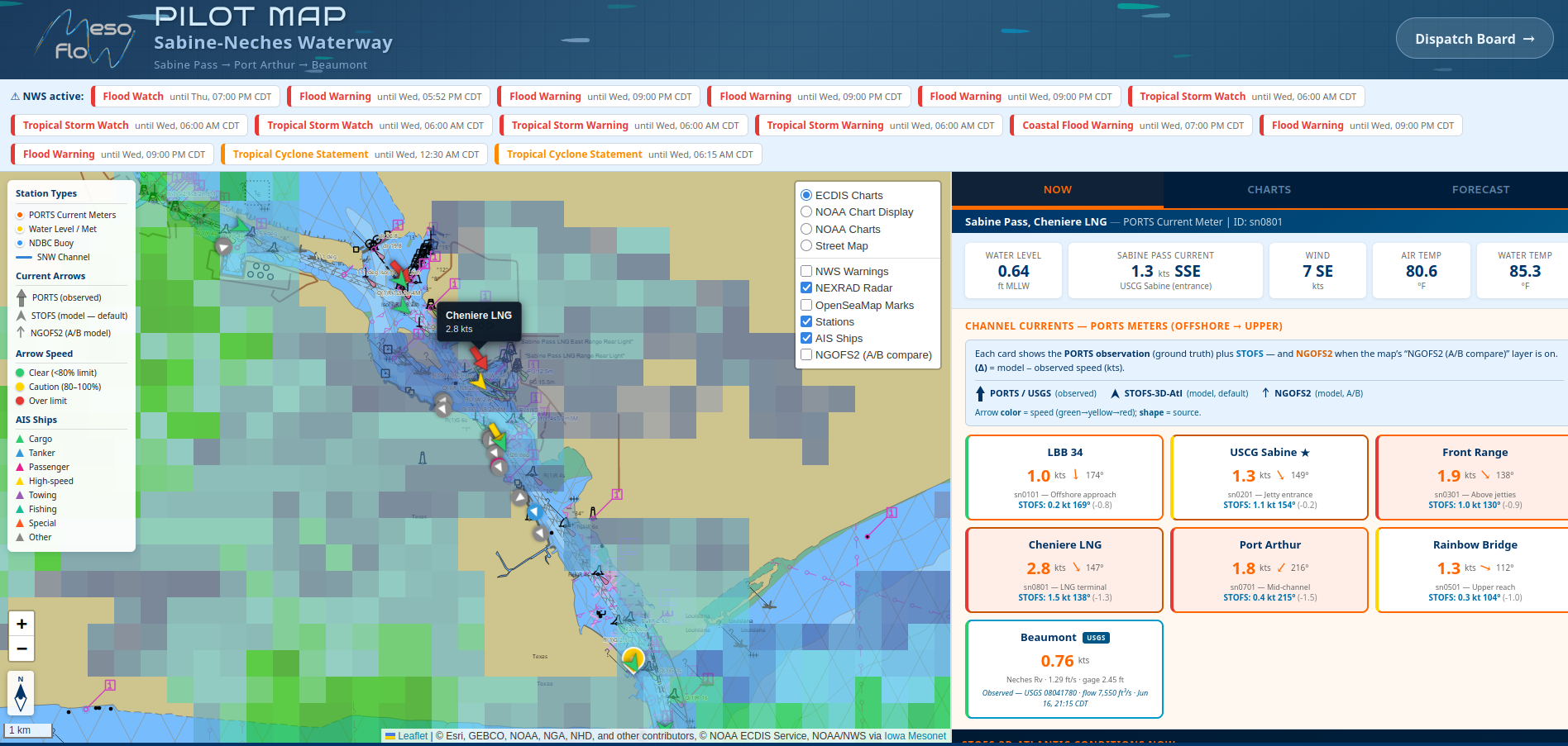
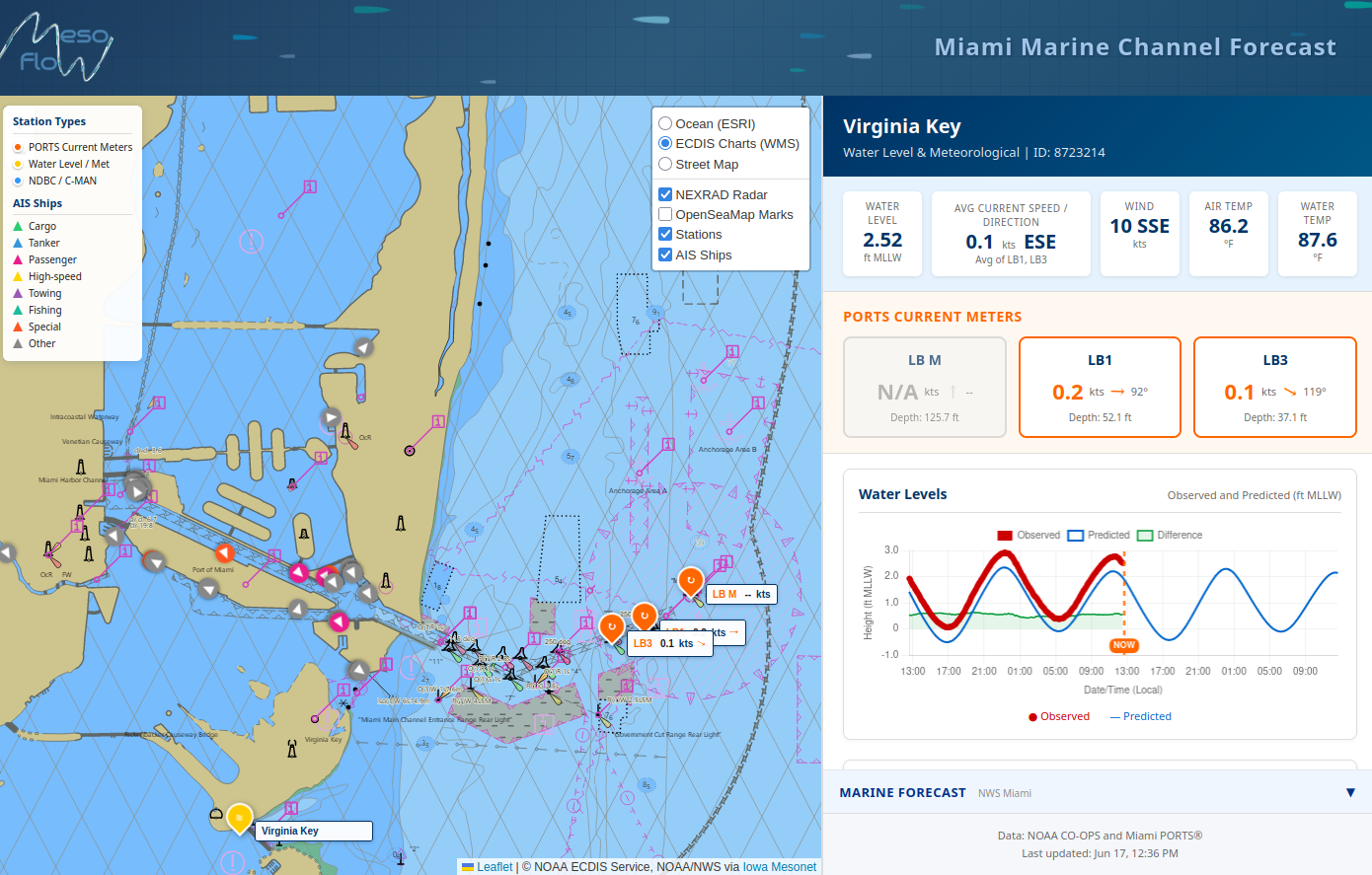
Marine Navigation Dashboards

Every pilot, the same picture. Real-time water levels, currents, weather and exception alerts—customized for your ship channel.

Mesoflow Dispatch Conditions Board — channel ribbon, alerts and gauges

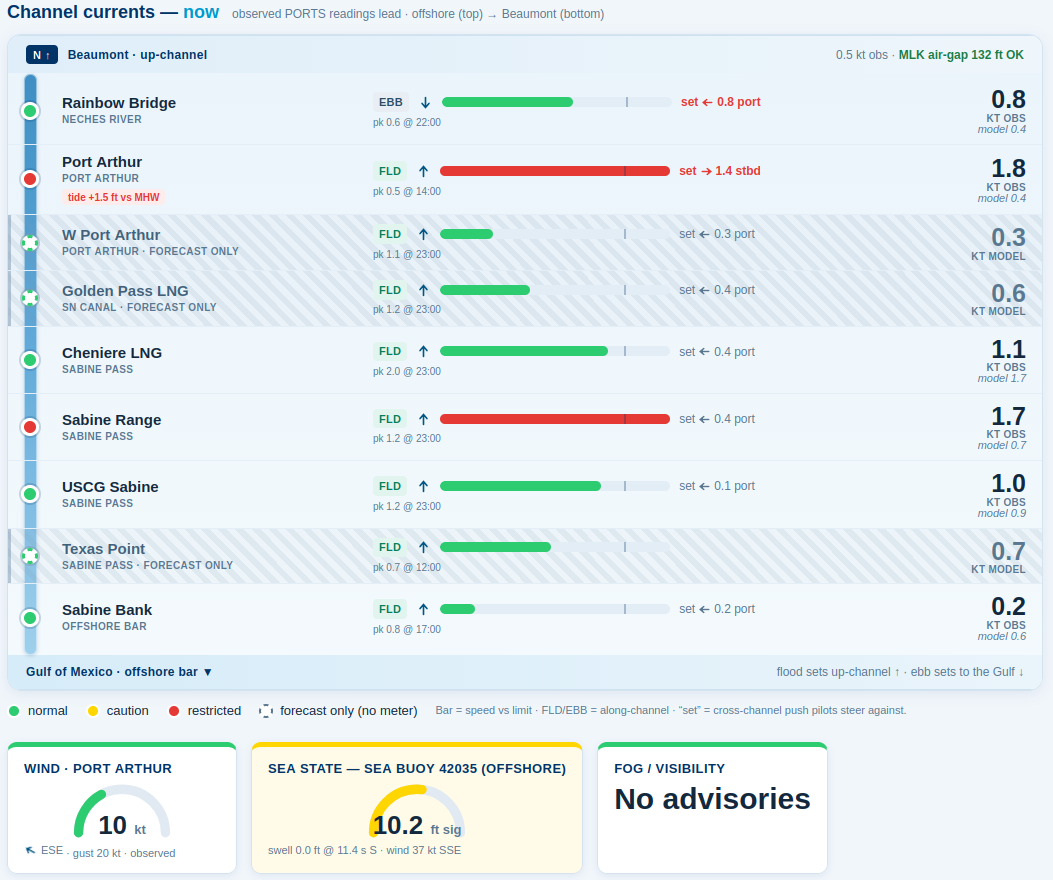
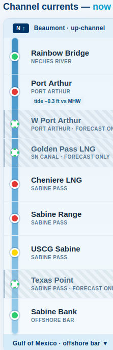
Information keeping ships under the bridges, over the rocks and safely in the shipping channel.
Built by former NOAA oceanographers — the people who installed and built CO-OPS navigation products.

Stop chasing data across a dozen websites

Safe, efficient transits depend on knowing the channel. We put the whole picture in one place.

The Challenge

To make safe navigation decisions, pilots and mariners need real-time data and forecasts for the ship channel. Manually checking many different websites is slow and unreliable. Safety and ship efficiency suffer when data is incomplete or delayed.

The Solution

A purpose-built data dashboard that aggregates ocean and atmospheric observations and forecast models into actionable channel information. Every pilot in your association sees the same live water levels, currents, wind and weather alerts—customized for your channel.

The Dashboards

Live examples built for the Sabine-Neches Waterway and Biscayne Bay. Yours would be tailored to your stations, thresholds and operations.

Conditions & planning

Dispatch Conditions Board

An observation-first board that answers the dispatcher's question at a glance: is the channel safe to transit, where, and when? The signature channel ribbon maps live currents to the physical waterway, with flood/ebb direction and the cross-channel set pilots steer against.

  • Live PORTS currents lead; model forecast clearly labeled as guidance
  • Color-coded exception alerts and a 36-hour outlook
  • Water level vs. MHW, wind, sea state and fog gauges
  • Compact NWS alert chips—expand for detail in one click
View live demo → Prototype — demonstration only
Dispatch Conditions Board with channel ribbon North-up channel ribbon on mobile - currents along the waterway
Live vessel traffic

Pilot Map

A real-time chart of your waterway with live AIS vessel traffic, currents, water levels and weather radar over ECDIS nautical charts. Tap any station for time-series detail—on the bridge, in the office, or at home.

  • Live AIS ship tracking with vessel-class coloring
  • NOAA CO-OPS currents & water levels; NDBC buoys
  • NEXRAD radar and NWS marine forecasts
  • ECDIS chart basemap; mobile-friendly
View live demo → Prototype — demonstration only
Pilot Map with live AIS vessel traffic
Where it started

Biscayne Bay & Miami

Our original marine navigation dashboard for the Port of Miami approaches—real-time currents, water levels, winds and forecasts with time-series charts. Proof that the same approach adapts to any port.

  • Real-time CO-OPS observations and predictions
  • Chart.js time-series for every station
  • AIS traffic, NEXRAD radar and NWS forecasts
  • Designed for any U.S. port or approach
View live demo → Prototype — demonstration only
Miami / Biscayne Bay marine navigation dashboard

Why Mesoflow

We are the oceanographers who built and installed NOAA CO-OPS navigation products.

Proven science, not experiments

Former NOAA oceanographers who understand near-shore dynamics. We use real-time NOAA data and aggregate sources NOAA PORTS doesn't—USGS, NDBC, NASA and forecast models—then synthesize it for your operations.

Built for your operations, not IT

Customized to your channel's stations and thresholds, tuned with your pilots. Every pilot uses the same dashboard—no guesswork, no in-house IT burden. Knowing the environment increases safety and efficiency.

60+
years of collective experience
2,000+
stations observed, Alaska to the Keys
Real-time
data refreshed continuously
NOAA
CO-OPS product builders

What every dashboard includes

Real-time data, refreshed continuously
Tidal & current predictions
Wind, wave & sea-state data
Storm-surge & threshold alerts
Mobile access — bridge, office, home
Synthesized model forecasts
Exception monitoring & dispatch view
Customized to your channel

Interested in a dashboard for your channel?

Request a free assessment of your pilot association's specific needs. We'll show you what a custom navigation dashboard could look like for your waterway.